产品
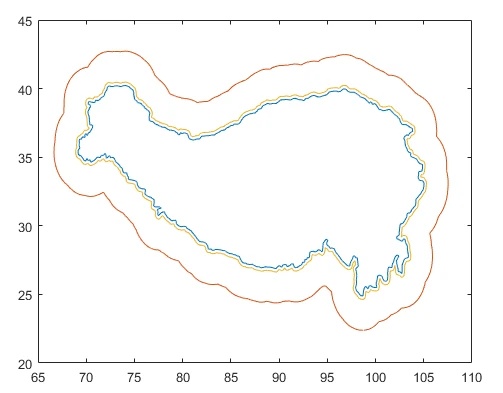
在地理信息系统中(GIS)中,我们一般使用ArcGIS对点、线、面要素进行缓冲区分析。这里我提供一个可以对封闭曲线进行缓冲区操作的matlab代码,具体的函数内容如下:
clear;clc;
%% Load original boundary data
border = load('Tibet_boundary.txt');
% sta_info=importdata('sites.info');
%% Generate a buffer with any radiuses for study area
d=2.5; % 2.5 degree buffer
polyout = polybuffer([border(:,1) border(:,2)],'lines',d);
out = inpolygon(polyout.Vertices(:,1),polyout.Vertices(:,2),border(:,1),border(:,2));
edge_points=[polyout.Vertices(~out,1) polyout.Vertices(~out,2)];
d=0.25; % 0.25 degree buffer
polyout = polybuffer([border(:,1) border(:,2)],'lines',d);
out = inpolygon(polyout.Vertices(:,1),polyout.Vertices(:,2),border(:,1),border(:,2));
edge_points1=[polyout.Vertices(~out,1) polyout.Vertices(~out,2)];
%% Plot original and extended boundary
figure('color',[1 1 1])
plot(border(:,1),border(:,2));
hold on
plot(edge_points(:,1),edge_points(:,2));
hold on
plot(edge_points1(:,1),edge_points1(:,2));
得到了青藏高原边界2.5°和0.25°的缓冲区

免责声明:本文系网络转载或改编,未找到原创作者,版权归原作者所有。如涉及版权,请联系删